


Not all Blue in Chefchaouen
(vero;2018-July-31)
.") Chefchaouen is known as THE blue city par excellence, pictures of its medina adorn multitude of blogs and it is often referred to as one of the most (if not the most) beautiful town in Morocco. And it's certainly true. Wandering through the old streets is a photographer's delight: blue and white houses, blue wooden doors, blue fountains, there is blue everywhere. The odd cat, cobbled streets, flowers and trees, colourful craft shops (not too many) make the whole a very picturesque experience.
Chefchaouen is known as THE blue city par excellence, pictures of its medina adorn multitude of blogs and it is often referred to as one of the most (if not the most) beautiful town in Morocco. And it's certainly true. Wandering through the old streets is a photographer's delight: blue and white houses, blue wooden doors, blue fountains, there is blue everywhere. The odd cat, cobbled streets, flowers and trees, colourful craft shops (not too many) make the whole a very picturesque experience.
However, we had a bad surprise when we arrived: the place was packed with Chinese tourists. Bad luck for us, we were full in the so-called Chinese National Day Golden Week.
This dampened our enthusiasm for the place a bit and after the obligatory exploration of the medina's maze of streets on our first day, we turned our attention to its surroundings, only returning to the old city for great people watching opportunities on Plaza Uta el-Hamman. We have pictures of the blue medina in the photo gallery dedicated to Tangier and Chefchaouen (from image 14).
After a frustrating search for an affordable hotel in the medina, we decided to stay outside at the hotel Rif on Avenue Hassan II, a good choice with a room providing nice views over the valley and the mountains. Our friendly host recommended some simple and good restaurants in the ville nouvelle, and that's where we spent all our evenings. We were there on September 30th, eight days after the Islamic New Year and the city was still celebrating with a funfair and merry-go-rounds on the market square. There were many Moroccan visitors and families who came here to enjoy themselves, with a lot of traffic in the streets, a great atmosphere. Strolling around Place Mohammed V in the evening was very pleasant indeed.
 On our second day we started our first hike (red dotted line on the map above) by trailing around with the stream of tourists to the Spanish Mosque, the obvious attraction outside the medina which offers great views on the town.
  From there, we followed white points until the village of Mechkralla, six to eight kilometers south-east of Chefchaouen. The going was easy on a dirt road for most of the time and we passed several fields of cannabis which, oddly enough, had a minty smell around them. This was a bit of a surprise as kif (hashish) is illegal in Morocco and drugs have been banned since 1974, but as always when it comes to economic necessities, the cultivation of cannabis is tolerated and Morocco is the world's top producer of kif, smuggling its production into Europe with speedboats via Spain. It is the main economic activity of the Rif region and prohibiting it would have disastrous repercussions on the livelihood of its inhabitants.
A shepherdess with her goats and men digging a very deep well into the ground were the only persons we met.
We had a great picnic in the shade of a big tree above the trail before reaching Mechkralla, finishing with some figs we had picked earlier from a tree. We also tried some cactus fruits. They tasted good but as poor Thomas discovered they are very difficult and painful to peel, even with a makeshift glove, as they are covered by a multitude of fine soft prickles. Not something to repeat.
 On the way back we spotted a farmer and his mule heading up a trail to our right. We decided to follow him and after a climb came to a plateau high above the town with more cannabis fields. We spent some time up there savouring the view over Chefchaouen before making our way down.
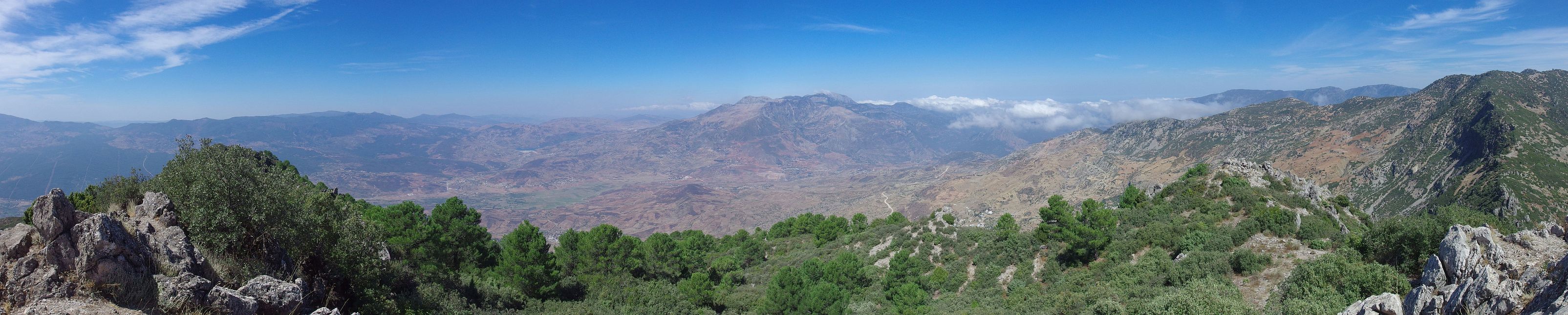
Our third day was Jebel El-Kelaa day (blue dotted line on the map). This mountain is 1616 metres high, which meant a climb of 1000 to 1100 vertical metres (and down again!). It was quite hot and it got really sweaty. We first walked on a dirt road which we left for a path in an hairpin bend. This path was easy to follow, passing a farm and bringing us eventually to a pass. After a short break we turned west and headed for the summit. This proved to be the hardest part of the day: the climb was quite steep and we kept losing the path which was hard to differentiate from the many animal tracks crisscrossing the slope. We became slower and slower as we had to go through stones and thicket. But it was really worth the effort: we reached the summit one hour after having left the dirt road and had a fantastic view on the surrounding landscape (see panorama below). However, it was so windy up there that we soon retreated to the pass where we had a long picnic before retracing our steps back to Chefchaouen.
As you might have guessed, the best memories we have from our stay in Chefchaouen are the two days we spent hiking in the hills around the city and our evenings outside the medina. Our two walks started from Chefchaouen and are easy to do on your own. Our host at Hotel Rif told us there were many other great trails a bit further away in the region, definitely doable on a day with a shared taxi. Something to consider if we ever come back to Chefchaouen.
| Panoramic view of the Rif mountains from top of Jebel El-Kelaa. Click on the panorama to open a larger version in a separate tab. Click again to activate scrolling in the full picture. |
 |
Want to read more? Go back to Crossing the Strait: Gibraltar to Tangier or go on to There is Something about Casa or go up to Blog
$ updated from: Blog.htxt Sun 24 May 2026 15:57:26 trvl2 — Copyright © 2026 Vero and Thomas Lauer unless otherwise stated | All rights reserved $