


Side Trip to Tilicho Lake
(vero;2017-Feb-28)
We have a photo gallery with pictures of this scenic side trip as well as panoramas of the Grande Barrière and Tilicho lake.
 Tilicho Lake has long been on our radar. It has been discovered in 1950 by the French Annapurna expedition led by Maurice Herzog as they were actually searching for the mountain. The maps they had at their disposal were wrong; based in Tukuche in the Kali Gandaki valley, they wondered whether they could at last discover the mountain from the other side of the massif in Manang. Some members separated and started for the Tilicho Pass which they wanted to cross before descending to Manang. Once over the pass they were surprised to find themselves on a wide plateau with a huge lake in the middle of it.
The expedition eventually succeeded in summiting on July 3rd. Herzog and his climbing partner Louis Lachenal were the first men to climb a peak over 8000 meters and paid their success dearly as they lost toes and fingers to the frost.
Following is an extract from Maurice Herzog's book “Annapurna, First Conquest of an 8000-meter Peak” (a worthwhile read) describing the moment where they came upon the lake:
- Here we had a surprise. According to the map, we ought to have been at the opening of a deep valley coming up from Manangbhot. Where was the wonderful view of Annapurna we ought to have had on our right? In some bewilderment we gazed at a dazzling scene of snow and ice where a galaxy of summits scintillated against the clear sky. It was a winter landscape, with something of fairyland in its brillance and clarity.
- On our right, instead of Annapurna, rose a gigantic barrier of mountains with many summits of about 7000 meters. Before us opened out no deep valley but a vast plateau in the centre of which was a great frozen lake covered with snow, its size difficult to assess. On the left, cliffs fell sheer to the immense white expanse of the lake.
Unfortunately, when we were in Manang in 1995 and 2001, there were no lodges after Khangsar which made the trip a bit difficult as we would have had to arrange camping and food. But this time, with newly built lodges at “base camp” two to three hours before the lake, it was clear that we would go.
 We leave Braga at 7am and at the entrance of Manang head west to follow the Marsyangdi river up valley. We are on a dirt road which ascends continuously and not too strenuously and brings us to the village of Khangsar. This is the end of the road and we are now on a good trail which we follow until we reach the building site of a big monastery. Then we start to gain height seriously and eventually arrive at the lodge settlement of Shree Kharka where we have a long lunch break.
.") After Shree Kharka the trail becomes very impressive as it narrows and skirts the mountain side precipitously: we can see the bottom of the valley steep below us and we have to cross a land slide area walking on a scree slope, wary of missing a step or sliding on the rolling gravel. Guidebooks warn about rock fall on this portion of the trek and make a scare out of it; we think it is a bit exaggerated but it is nevertheless good advice to get over this portion very quickly and to start early when there is snow around.
After Shree Kharka the trail becomes very impressive as it narrows and skirts the mountain side precipitously: we can see the bottom of the valley steep below us and we have to cross a land slide area walking on a scree slope, wary of missing a step or sliding on the rolling gravel. Guidebooks warn about rock fall on this portion of the trek and make a scare out of it; we think it is a bit exaggerated but it is nevertheless good advice to get over this portion very quickly and to start early when there is snow around.
We pass some porters who are having a break before entering the difficult passage and as we turn back later on we can see them carrying their huge loads on the precarious path and cannot help but feeling anxious for them. We let a man leading a horse overtake us: it is too dangerous for him to ride this part of the way.
 We arrive at base camp at 3.30 pm and there are quite a few trekkers around. As usual, the first big lodge is quite busy and there are two others a bit further on. A fourth is being built: incredible! We end up staying at the second lodge. The weather during the day is not too bad but clouds are hiding the summits around us. It starts raining at the end of the afternoon and we wonder whether it is a good sign for tomorrow or not.
Clouds are low when we wake up the following morning. We are really hesitating whether it is worth the effort to go to the lake. The group of five Israeli young men whom we have known for a few days now is definitely going up: they want to spend the night in Shree Kharka and that is their only chance. We watch them getting ready and after they're gone decide to try our luck as well. Who knows… on the Grande Barrière.")
It has snowed during the night and there is a layer of snow covering the slopes as we ascend. The way is fairly easy and the real strain comes from the height: the lake is situated at an altitude of 4,919 metres. This is not a problem for us: we are acclimatised from Manaslu and never have had any problem with altitude sickness but we see some trekkers abandoning and re-descending to base camp. We finally arrive on the lake shores after two hours twenty minutes. Our Israeli friends greet us cheerfully and, right on cue, the clouds lift and we can see the lake.
The left side is most beautiful with a glacier ending in the lake and its ice blocks boasting nice ring patterns. The right side is flat: that's where Herzog and his team came from. We stay as long as we can and admire the scenery but it is quite cold and after an hour we start to retrace our steps to base camp.
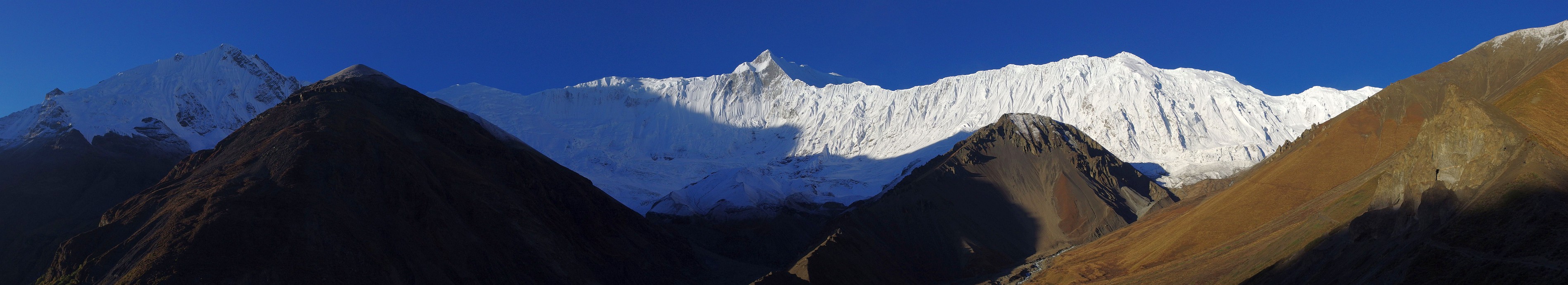
The clouds continue to lift and we see more and more of the scenery as we descend. We spend a lot of time on a spur above base camp watching the clouds drift and catching some glimpses of the mighty chain of summits to our left: the so-called Grande Barrière.
The weather is perfect when we wake up the next morning. Should we go to the lake again for a perfect view? We decide against it but go back to the spur from yesterday afternoon and watch the sun rise over the Grande Barrière.
| The Grande Barrière in the morning sunshine: (clicking on the panorama opens a larger version in a separate tab, click again to activate scrolling in the full picture). |
 |
We don't need to return to Manang to regain the Annapurna Circuit. We first go back to Shree Kharka: the dangerous landslide area with the scree does not seem as long as two days ago. The walking is great. There are no clouds around as we skirt the Grande Barrière and we can see far down the valley past Manang and Braga. In the distance we can even spot the summits of the Himal Chuli and Manaslu.

 We make a long break in Shree Kharka and instead of continuing down valley to Manang, we continue on a path skirting the slope without losing much height until Upper Khangsar.
The landscape is as impressive as before with the Manang valley ahead. We keep turning back to catch a last glimpse of the Tilicho valley and the Grande Barrière and as we progress we can see Annapurna 3 appearing little by little before us.
We even see a few blue sheep grazing above us, this is a perfect day. Upper Khangsar is a picturesque medieval ghost village where all the houses seem to be empty or abandoned.
The path reaches a jutting spur shortly after and the Thorong valley comes into view. We make a short break and soak the superb scenery for a last time before starting the steep descent to the Thorong river. We cross the river and have to climb again to regain the main trail.
Don't forget to check our photo gallery for more pictures of this scenic side trip as well as some panoramas of the Grande Barrière and Tilicho lake.
Go back to From Dharapani to Manang or go on to From Manang to Kagbeni
$ updated from: Around Annapurna.htxt Sun 24 May 2026 15:57:27 trvl2 — Copyright © 2026 Vero and Thomas Lauer unless otherwise stated | All rights reserved $