Welcome  FAQs
Links  News

Turkey 2015

A very diverse trip combining a bit of the Mediterranean, a lot of Cappadocia and a dash to the Armenian border for the ruins of Ani.

We made our way back to Istanbul along the shores of the Black Sea with a few stops inland.

Check our Turkey 2015 pages for our itinerary, a few stories and many pictures.

Full map of all Turkey 2015 pages

Other Things

Translate & Share

Path: Photos > Valleys of Cappadocia > East of Göreme: Red and Rose valleys, White Mountain and Zelve
Tags: Turkey  2015

East of Göreme: Red and Rose valleys, White Mountain and Zelve


(vero;2020-May-20)

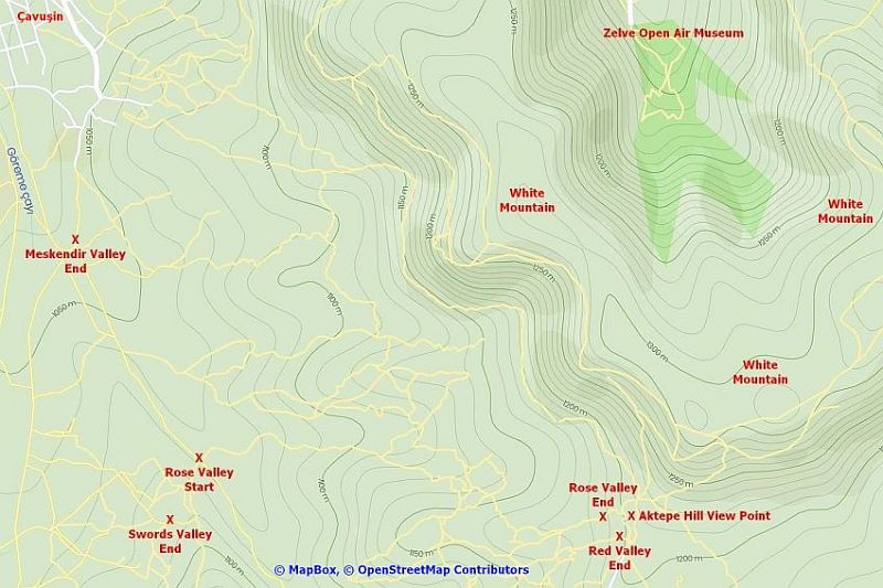
The main feature east of Göreme is the White Moutain. There are many routes to get there: the Red, Rose and Meskendir valleys all end on this plateau. Following the trails is not always obvious and one might end up more than once at the end of a valley with no exit to the top. In that case, there is no other way than retracing one's steps and take a different direction at the first fork you encounter. A smartphone with GPS and offline maps from OsmAnd (which we recommend highly) is most useful in that area. The region is wide and extends to the Zelve Open Air Museum, the fairy chimneys of Paşabaği and the Dervent valley. We have explored all the area on foot but have sometimes done some hitch-hiking to reduce distances, for example between the Dervent valley and the Zelve/Paşabaği area. See the map showing the area east of Göreme below the photo gallery for planning purposes.

The so-called dove complex just outside of Göreme. It is a collection of rock-hewn dovecotes with the odd ruined church hidden in-between.
Rest of a church in-between the dovecotes of the dove complex. Heading into Meskendir valley, direction White Mountain. Orchard in Red valley. Exiting Red valley before reaching the plateau of the White Mountain. Uçhisar castle in the distance. A church somewhere in Red valley. View of the Red/Rose valleys on the way to the White Mountain. View of Red valley seen from a path skirting the edge of the White Mountain. Finally arriving on the plateau of the White Mountain. A path skirting the edge of the White Mountain. The steep walls of the White Mountain. View from the White Mountain. Uçhisar castle in the distance (top middle of the picture). The fairy chimneys of Paşabaği seen from the White Mountain. A very inviting trail seen from the White Mountain. On top of the White Mountain. View of the Zelve area from the White Mountain. The road ends at the Zelve Open Air Museum (left of the picture). The Rose valley. The village of Çavuşin on top left of the picture. Leaving Çavuşin for the White Mountain following trails along Rose valley. Walking along Rose valley. Walking along Rose valley. Walking along Rose valley. Aerial view of Rose valley from the White Mountain. Going down to the village of Çavuşin which can be seen at the top right of the picture. Open Air Museum of Zelve. Open Air Museum of Zelve Open Air Museum of Zelve Open Air Museum of Zelve Open Air Museum of Zelve The fairy chimneys of Paşabaği. The fairy chimneys of Paşabaği. The fairy chimneys of Paşabaği. The fairy chimneys of Paşabaği. A rock-hewn church in Paşabaği. View of Dervent valley with its fairy chimneys and weird rock formations. Fairy chimneys in Dervent valley. Walking along Dervent valley. Walking along Dervent valley. Rock formations in Dervent valley. Dervent valley: a seal, obviously.
Snapshot of the map showing the area east of Göreme

To expand the snapshot to a complete full size map, simply click on the picture. This will open the map in a separate tab: click again to navigate in the full map using the bottom and right scrollbars.

A snapshot of the area east of Göreme

[Go to Top]

Go back to Göreme to Ortahisar: Meskendir valley and Hallaç Monastery or go on to Panoramas of Cappadocia or go up to Valleys of Cappadocia


$ updated from: Valleys of Cappadocia.htxt Fri 16 Aug 2024 15:40:10 trvl2 — Copyright © 2024 Vero and Thomas Lauer unless otherwise stated | All rights reserved $