Welcome  FAQs
Links  News

Turkey 2015

A very diverse trip combining a bit of the Mediterranean, a lot of Cappadocia and a dash to the Armenian border for the ruins of Ani.

We made our way back to Istanbul along the shores of the Black Sea with a few stops inland.

Check our Turkey 2015 pages for our itinerary, a few stories and many pictures.

Full map of all Turkey 2015 pages

Other Things

Translate & Share

Path: Photos > Valleys of Cappadocia > Göreme to Ortahisar: Meskendir valley and Hallaç Monastery
Tags: Turkey  2015

Göreme to Ortahisar: Meskendir valley and Hallaç Monastery


(vero;2020-May-20)

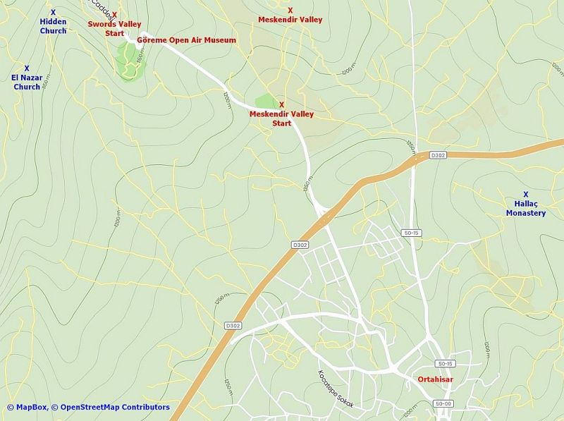
There are two obvious routes to hike from Göreme to Ortahisar (three if you count the road…). The first route could be via the Meskendir valley: starting from Göreme find your way to the start point of the Rose valley via the dove complex (a collection of rock-hewn dovecotes) and follow the Meskendir valley, eventually finishing at the road leading to the Aktepe Hill View Point. The second route could be via the ridge running west of the main road to Ortahisar: start from the Hidden Church and follow the trail affording views of the Open Air Museum and ending on the D302. Cross this road to enter Ortahisar and find your way to the castle. Whatever route you take, make sure to make a detour to the Hallaç Monastery. See the map showing the area between Göreme and Ortahisar below the photo gallery for planning purposes.

There are also nice walks to do from Ortahisar following trails to Ibrahimpaşa or Ürgüp (quite rewarding via the Pancarlık Church). A nice itinerary for a long walk would be starting in Göreme, following the Zemi valley to the D302, continuing to Ibrahimpaşa and Ortahisar and returning to Göreme via one of the two routes mentioned above.

Ortahisar castle towering over the village.
Overall view of the village of Ortahisar. Strolling along the trails at the base of Ortahisar Castle and as usual dovecotes everywhere. Dovecote cut into the rock near Ortahisar Castle. Strolling along the trails at the base of Ortahisar Castle. Hallaç Monastery south of the road linking Ürgüp and Ortahisar. Hallaç Monastery. Inside Hallaç Monastery. Inside Hallaç Monastery. Hallaç Monastery. Hallaç Monastery. Hallaç Monastery. Hallaç Monastery. Hallaç Monastery. Hallaç Monastery. Returning to Göreme following trails on the plateau west of the road linking Ortahisar to Göreme. Returning to Göreme following trails on the plateau west of the road linking Ortahisar to Göreme. Returning to Göreme following trails on the plateau west of the road linking Ortahisar to Göreme. Note the coach leaving the Open Air Museum and going up the road in the direction of Ortahisar on the top right of the picture. Returning to Göreme following trails on the plateau west of the road linking Ortahisar to Göreme. The Open Air Museum on the right, the White Moutain with the Rose/Red valleys “flowing” down to the plain. On the left in the vertical middle, hard to see, you can spot Çavuşin. Returning to Göreme following trails on the plateau west of the road linking Ortahisar to Göreme. View of the Open Air Museum. Returning to Göreme following trails on the plateau west of the road linking Ortahisar to Göreme. Returning to Göreme following trails on the plateau west of the road linking Ortahisar to Göreme. Dovecotes, churches and rock dwellings everywhere. Returning to Göreme following trails on the plateau west of the road linking Ortahisar to Göreme. View of the White Moutain and the Rose/Red valleys. The Hidden Church. The Hidden Church. Top of Meskendir valley, view of the rock of Uçhisar in the distance Returning to Göreme following Meskendir valley (seen here from the top). This valley runs east of the road linking Ortahisar to Göreme. Descending into Meskendir valley. Descending into Meskendir valley. The way is not always obvious and can involve some scrambling or sliding! Walking along Meskendir valley. Walking along Meskendir valley. Walking along Meskendir valley, dovecotes everywhere. Walking along Meskendir valley: more dovecotes. Walking along Meskendir valley. Walking along Meskendir valley. Walking along Meskendir valley. Walking along Meskendir valley. Walking along Meskendir valley. Colourful rock formations in the Meskendir valley.
Snapshot of the map showing the area between Göreme and Ortahisar

To expand the snapshot to a complete full size map, simply click on the picture. This will open the map in a separate tab: click again to navigate in the full map using the bottom and right scrollbars.

A snapshot of the area between Göreme and Ortahisar

[Go to Top]

Go back to Göreme to Uçhisar: Love, Pigeon and Zemi valleys or go on to East of Göreme: Red and Rose valleys, White Mountain and Zelve or go up to Valleys of Cappadocia


$ updated from: Valleys of Cappadocia.htxt Fri 16 Aug 2024 15:40:10 trvl2 — Copyright © 2024 Vero and Thomas Lauer unless otherwise stated | All rights reserved $