


From Kagbeni to Pokhara
(vero;2017-Feb-28)
This part of the circuit is definitely an anticlimax after the highlights of the previous week. It all starts with the dirt road linking Kagbeni to Beni which is plied by numerous buses, lorries and jeeps, all whirling dust clouds and splattering with mud as they drive past people and villages. Most tourists follow the advice of their guide book and finish their trek in Muktinath or Jomson where they take a bus to Pokhara or Kathmandu. We decide to walk to form our own opinion. The trail has been partly re-routed to the other side of the Kali Gandaki and we have mixed feelings. It has been purpose laid and feels artificial: even before the road came, villagers would cross the river to join the main trail on the other side and they still do. Which means that since it is not used by locals the path is not well maintained: land slides are not cleared and it disappears sometimes as trees fall on the track forcing a detour which is not always well marked… The alternative on the other side is utterly unpleasant and the valley has been clearly scarred by the road; villages have lost their character and shacks have sprouted along the road in the form of unsightly iron corrugated sheds selling snacks and alcohol, visited by idle men who pass the time drinking and getting nowhere.
The second part after Tatopani gets better as we leave the road. But it is a highly touristy area with too many groups to our taste and we miss the spectacular landscape of Mustang and the Manang side although, to be fair, we had a spell of bad weather and mountain views were hard to get.
From Kagbeni to Pokhara (10 days, 01 Oct 2016 to 10 Oct 2016)
01-04 Oct: Kagbeni (2800m) to Chitre (2500m)
Check our panoramas page for views of Dhaulagiri.
To avoid the road and the strong winds which are known to blow up the Gandaki valley, we decide to take an alternative route to Jomson. We follow the road until Ekle Bhatti where we cross the river, then pass through the villages of Pangling, Phalyak and Dhagarjung, go up the mountain to a pass overlooking Jomson and descend to rejoin the road.
 The route up is very pleasant, not too strenuous and passing through nice villages. The view at the pass is particularly fine: we see the Nilgiris, have a last glimpse into Mustang and below us lay Jomson and the Gandaki valley. We are not alone: a big dog sees us in Ekle Bhatti and follows us up the mountain. We love walking with dogs, it happens from time to time and it always feels special. In honour of the German climber Reinhold Messner, we give those dogs a name: Reinhold, or if it's a she as today, Reinhild.
The way down the pass is difficult and very steep and Reinhild keeps waiting for us. We lose the path and the slope is full of stones rolling under our shoes. We are glad to reach Jomson at last. We stop at the airport for a permit check and that's where Reinhild leaves us: she will probably rejoin Ekle Batthi following the valley.
We head for Marpha and after a while on the road take a detour on a path over the road. It is signed blue and white and passes through the village of Syang: much better but also tiring with many ups and downs.
 Fortunately the road by-passes Marpha and the village is still intact. We see many tourists who seem to come here for lunch on a day-trip from Jomson. We find that the village has lost some of its charm and has turned into a kind of small open-air museum. The main street is now lined with restaurants and souvenir shops but it is not all that bad and it is obvious that there is still life in the village: the fields and orchards around the village are cultivated and we can see people tending their gardens We visit the gompa which has been renovated and commands a nice view over the village.
It rains when we wake up the following morning and we wait until it stops to leave Marpha. We take the new trail on the other side of the river. It has been established 2011 and is quite pleasant although much more tiring as the old one: the river bank is quite steep and we are forced to go up a mountain and down again to follow the course of the valley. We can see the village of Tukuche on the other side as we go up. The going gets a bit frustrating as we gain a lot of altitude but no horizontal distance: Tukuche remains on our right for ages and we have the feeling of not making any progress at all. There is a landslide just before the village of Sauru and the path is blocked by rocks and fallen trees which we have to climb over or detour which slows our progress.
. Dhaulagiri with its white summit can be seen between the trees on the right.") We make a break in Kokhekhanti where the river bank gets wider. We can even see Dhaulagiri and the icefall when they appear between the drifting clouds. We cross the river and rejoin the main path shortly before Kalopani and start looking for a lodge to stay for the night. The smaller lodges are all closed. Some houses still have a sign on their facade but they are not operating anymore. So we are confronted with a choice of big lodges, mostly empty, unfriendly and incredibly expensive: there are simply not enough trekkers to sustain them all. We continue until Lete where we find at last a small lodge which is still open. We stay there for the night and regret our choice: the rooms are dusty, the dhal bhat scarce and not very good and we are still hungry when we finish our plates. For once we think we would have been better off in one of the bigger lodges.
We make a break in Kokhekhanti where the river bank gets wider. We can even see Dhaulagiri and the icefall when they appear between the drifting clouds. We cross the river and rejoin the main path shortly before Kalopani and start looking for a lodge to stay for the night. The smaller lodges are all closed. Some houses still have a sign on their facade but they are not operating anymore. So we are confronted with a choice of big lodges, mostly empty, unfriendly and incredibly expensive: there are simply not enough trekkers to sustain them all. We continue until Lete where we find at last a small lodge which is still open. We stay there for the night and regret our choice: the rooms are dusty, the dhal bhat scarce and not very good and we are still hungry when we finish our plates. For once we think we would have been better off in one of the bigger lodges.
We settle for a boring unfriendly evening when a small Suzuki Alto stops in front of the lodge and a man comes in looking for a room. It is dark and he wants to stay for the night with his family: father, mother, teenage son and daughter. The father is contractor and tells us that he builds bridges; they are now on holiday on their way to Muktinath. We chat while they are waiting for their food and we see light as we suddenly get a dhal bhat refill from our hosts…
.") We have nice views on Dhaulagiri as we wake up the next morning. After Lete we take the forest trail to Ghasa to avoid walking on the road. It climbs quite steep and is very, very muddy. Memories of Manaslu come back to us! The path soon peters out and loses itself through the vegetation: again a case of bad trail maintenance but we do not mind for once and are relieved when we regain the road and feel solid ground under our feet. We cross the river to rejoin the other bank as soon as possible and the path is good with tiring ups and downs in the afternoon. It is hot and we sweat profusely. We notice that many people are repainting their houses in white in the villages which we pass through: this must be the season to do so, now that the monsoon is over.
We have nice views on Dhaulagiri as we wake up the next morning. After Lete we take the forest trail to Ghasa to avoid walking on the road. It climbs quite steep and is very, very muddy. Memories of Manaslu come back to us! The path soon peters out and loses itself through the vegetation: again a case of bad trail maintenance but we do not mind for once and are relieved when we regain the road and feel solid ground under our feet. We cross the river to rejoin the other bank as soon as possible and the path is good with tiring ups and downs in the afternoon. It is hot and we sweat profusely. We notice that many people are repainting their houses in white in the villages which we pass through: this must be the season to do so, now that the monsoon is over.
We want to spend the night in Dana but we somehow miss the place: difficult to know when to cross the river and although people tell us we are in Dana, we do not recognise the village where we stayed in 1995 and 2001: it must be higher than the road and we missed the connecting trail… We continue to Tatopani. Although the road avoids the village and the cars and motorbikes are parked in a huge open space below it, the village has lost much of its old charm. There are many new big lodges lining the main street, some still under construction, and the place is brimming with tourists,locals and foreigners alike.
We are happy to turn East and leave the road the following day. This is supposed to be a hard day as we have to climb from Tatopani (1200m) to Ghorepani (2850m), so we leave early in an attempt to avoid the heat. We are fit and gain altitude quickly. But it is really hot! The trail is in a good state and there are many chautaris along the way, most of the time at scenic spots. We keep bumping into a dirt road which snakes all the way up to Ghorepani but fortunately there are no vehicles using it (yet). We see mule trains: loaded on the way up and empty on the way down.
We make a break at around 2 pm in Chitre (2500m) in the garden of the Annapurna lodge and find the place so inviting with its scenic view on the valley and its friendly hosts that we decide to stay for the night. The decision is easy because we have never liked Ghorepani, an overcrowded and expensive lodge settlement with horrible corrugated iron architecture, where most people stay in order to climb to the famous Poon Hill view point in the early morning to watch the sun rise over the Annapurnas …
It rains quite heavily at the end of the afternoon but not enough to clear the sky and give us perfect views: the summits and higher grounds are draped in mist.
Don't forget to check our panoramas page for views of Dhaulagiri.
05-10 Oct: Chitre (2500m) to Pokhara (807m)
We have some panoramas showing views of the Annapurna range along this part of the trek.
Our destination the next day is Ghandruk. We leave Chitre and make good speed to Ghorepani. We arrive there at 8.30 am and cannot believe what we see: the place is utterly full with trekkers. Most of them have done the Poon Hill trip in the early hours and after a rewarding breakfast are about to leave for Tadapani and Chomrong. This is a shock for us: the Annapurna Circuit was empty in comparison and the type of trekkers we are meeting now is completely different to the ones we have seen so far. They are mostly in groups, some quite big, with guide and porters and we also see for the first time in Nepal huge groups of Chinese trekkers.
 We leave Ghorepani and follow the crowds. The path climbs up and gains a ridge and we should have nice views, alas this is not the case today. It is misty and the going is horrible: we are in a huge queue, each trekker following blindly the trekker in front of him. Some make frequent breaks, conglomerating on the side of the trail, or simply stop in the middle of the path to gather breath. And because most of them are in groups, they are really difficult to overtake. We hate it, there is no word to express our frustration. We are fit and go in fifth gear to overtake them all but, going at such a pace, passing all those people is really not enjoyable. At last we have passed nearly all of them and the going gets better. We make a long break in Tadapani and leave when the first groups start to arrive.
 The trek down to Ghandruk reminds us of Manaslu: no views whatsoever, mud everywhere and slippery trails. We have the feeling we will never arrive! As we near the village, we come to a big board showing a map of the place and the location of the lodges: there are dozens of them, for sure over fifty. The way splits: we can either continue where most lodges seem to be, or turn left in the direction of fewer lodges. We go left and go steeply down hill eventually reaching the Meshram Barah temple and this is another steep flight of steps until we reach a level trail. We are not sure where we are, turn right and finally arrive at the beginning of Ghandruk. We are a bit nervous as there are only a few lodges around: we are afraid we might have to climb again. And then we see it: this is the lodge where we stayed back in 1995 and from which we have very fond memories. Strangely enough we had not been able to find it in 2001 but this makes sense as it is a bit aside of the centre of the village. We check the place and stay there: it is still a small family run lodge with all rooms (seven or eight of them) opening on a veranda affording direct views of the mountains (not today with the clouds) and very reasonable prices. They have modernised and there is now a bathroom with hot shower and two toilets at the end of the veranda: no need to go in the garden anymore. We are very happy to be here.There are other guests with us: a Danish family with two kids, an American one with one toddler and a Canadian one with two more kids. Three independent German trekkers arrive after us. All in all a very pleasant company. It rains during the afternoon and after a lull in the evening again: no mountain views for today …
It is not better when we wake up the following morning: heavy and steady rain. For God's sake! we are now October 7th and the monsoon should be long over. Everybody in the lodge is waiting. The three young German decide to go at 9.30 am while the rest of us still hesitates and finally decides to have a rest day and wait it out. The rain finally stops around 11.30 and we set off to explore the village for two hours or so. Water is dripping everywhere and the village lanes paved with stone slabs are slippery. The day is pleasant nevertheless: the kids are playing in the lodge and bring a lot of animation, it is a peaceful day. The cloud cover thins at the end of the afternoon and we can even glimpse some moutains from time to time. There is hope for tomorrow!
.") And as we open the window at dawn the next morning we can see the mountains at last: Annapurna South, Himchuli, Fish Tail. Good that we are up so early because the clouds reappear quickly and hide them again. But we're happy, we have seen them. We have a lot of time on our hands and decide to go to Landruk which is not far away on the other side of the valley. We watch the families getting ready to leave, the Danish one is also going to Landruk, so we will probably meet again. We are a bit sad to leave this lodge. It was perfect: small, friendly, welcoming and had the best hot shower ever. The views this morning right out our window were as we remembered them from all those years before, the veranda as pleasant. The young man managing the lodge has taken over from his family 6 months ago. He is very enthusiastic. He tells us that he does not want to make his lodge too big: he likes his job and wants to be able to communicate and interconnect with his guests. He wants to learn from them and give them what he can to help them understand Nepal. We hope he will remain that way because so far, he is on a very good track.
And as we open the window at dawn the next morning we can see the mountains at last: Annapurna South, Himchuli, Fish Tail. Good that we are up so early because the clouds reappear quickly and hide them again. But we're happy, we have seen them. We have a lot of time on our hands and decide to go to Landruk which is not far away on the other side of the valley. We watch the families getting ready to leave, the Danish one is also going to Landruk, so we will probably meet again. We are a bit sad to leave this lodge. It was perfect: small, friendly, welcoming and had the best hot shower ever. The views this morning right out our window were as we remembered them from all those years before, the veranda as pleasant. The young man managing the lodge has taken over from his family 6 months ago. He is very enthusiastic. He tells us that he does not want to make his lodge too big: he likes his job and wants to be able to communicate and interconnect with his guests. He wants to learn from them and give them what he can to help them understand Nepal. We hope he will remain that way because so far, he is on a very good track.
 Something funny happens when we leave Ghandruk. I am going down steps on the main trail when Thomas shouts to make way but it is too late… A Nepali with a sheep on a leash is already overtaking me on the left with a small problem: the sheep has decided to go between my legs and tries to make his way forcefully, the leash stuck at my left leg. There is an interesting moment, a split second when both the sheep and I are balancing on the edge of the step, I can see us tumbling down the trail and finally manage to keep the sheep steady while the Nepali hurries to get it back. It finally passes through my legs: I should have sat on it and galloped down the trail! I cannot stop laughing once the first scare is over!
The way down the river is quite steep. We make a long break before starting the climb (in full sun) on the other side. We settle in a big lodge where we are the only guests with the luxury of an attached bathroom with bath tub. We can't believe it! And it only costs 100 Rs: the owners seem to be desperate for customers. To be fair, the bath tub looks better as it is: the water takes hours to flow down so that the second person having a shower is wading in the dirt water of the first one. We stroll through the village and eventually see the Danish family in another lodge: we spend the rest of the afternoon in their company. We are quite impressed how well the children (Albert eight and Ella four) are going and seem to enjoy trekking. Their parents Tine and Mikael met 8-9 years ago when they were both working for a Danish NGO in Nepal. They stayed two years and it is very interesting to hear about their experience and thoughts.
 and Himchuli (taken from our lodge in Landruk).")

The trekkers we see on the trail have changed since Ghorepani: there are too many groups which are in a world of their own and the rest divides between the ABC trekkers (Annapurna Base Camp) and the “loop trekkers” who spend around 5 days in the foothills, with Ghorepani and Ghandruk as a highlight. As usual very few trekkers carry their own bags, although, funnily enough, the three families we met were all carrying their own stuff. And all of them share one characteristic: they are “traumatised” by the huge Chinese groups. We never had the pleasure ourselves but most people we talk to have horrendous tales of evenings spent with Chinese groups and their only fear is to see such a group arrive at their lodge, which is why the first question they ask when choosing a lodge is: are you expecting a Chinese group? Must be worse than the Israelis at Thorong Phedi!
The rain has brought back some unwelcome guests: the leeches are out in force and every evening we count how many suction marks we have. Leeches release an anaesthetic when they start sucking blood which is the reason why we don’t feel them when they bite until we see blood on our legs or staining our socks.
 Our Danish friends tell us that the mountain views from Australian Camp are quite good and we decide to stop there on the following day instead of continuing to Dhampus as we had planned. This is a short walking day again. It starts well in the morning with views to Annapurna South and Himchuli but again, clouds gather and the moutains disappear. The trail leaves the valley of the Modi Khola and we have to climb 500 altitude meters up to Deorali (meaning pass in Nepali) before descending to Australian Camp. It is frustrating: the ridge around Deorali and the pass are both misty and cloudy and we see nothing. It is grey and cold as we settle in the lodge at Australian Camp where the Danish family soon joins us.
There is a bamboo swing in the garden: those swings can be seen everywhere during Dashain, a fifteen day long festival, one of the most important in Nepal. They are constructed with traditional methods and materials (ropes made from strong grass, bamboo sticks, wood) a week before Ghatasthapana (the first day of Dashain, this year October 1st) and dismantled only after Tihar, the festival of lights which lasts five days, this year from October 28th to November 1st.
 It rains in the evening and during the night and we have a good surprise the next morning: the mountains are free and we can see Annapurna South, Himchuli, Gangapurna, Annapurna 3 and Fish Tail. We are glad we followed the advice of Tine and Mikael. We leave the lodge at 8.00 am and quickly reach the road where buses and taxis are waiting at the trail head to drive trekkers back to Pokhara. But we want to continue and walk the whole way to Pokhara. We go for a while along the road and soon find a trail going parallel and even short cutting the road bends. A taxi passes us and honks as we approach Nautanda: our Danish friends wave us good bye and speed away!
 We make a break in Nautanda and buy some biscuits. People are gathered in a big group at the road side and we feel that something odd is going on. A tea shop owner tells us that a 8-year-old little girl of the village has been raped and killed last night. The culprits, two family members who were visiting for the Dashain celebrations, have been arrested and we can see how a young man (her brother) holding tightly the small corpse in a blanket is boarding a taxi with police men inside. The mother collapses to the ground as the car departs. What a tragedy.
In Nautanda we take a dirt road which runs along the ridge until it reaches Sarangkot, 10 kilometers away, where we want to spend our last night on trek. There is a regular traffic and we pass many farms and some villages. Everybody is preparing the big Dashain day which will be in two days time: we see many goats being killed, motorbikes overtake us with goats fastened on the backseat and driven to their death. Kids are on holiday back from boarding schools and play around, we meet full families having a stroll, it feels much like our Xmas back home.
We hear people shouting at us as we approach Sarangkot: they ask whether we are looking for a room and tell us that we could stay at their place. We hesitate and follow them to have a look: they are running a homestay with two nice clean rooms and we decide to stay instead of looking for a lodge further on. This is the perfect show down for our trek. Things are changing fast in Sarangkot. A huge hotel complex (Chinese) is being built 200 meters from the house where we stay, there is a zip-line on the ridge above the house and we spend some time watching people hurling down into the valley. We stroll to the view point and can see how Pokhara is ever growing: we see 6 storey hotels, many building sites and hear that there are plans to build a cable car from Lake Side to Sarangkot. We are far away from the Pokhara we first saw in 1994…
Our homestay family has also a small shop and local people, probably workers from the nearby building site, come for a drink or a snack. They have a daughter (15) and a son (18) and are farmers: they own a few fields, have banana trees, a cow with a calf and chickens. Staying with them was a good idea. It starts to rain heavily at 7.30 pm until after midnight. The sound of the falling rain on the iron corrugated roof is deafening and it is so impressive that we start to worry that the slope where the house is built might be caught in a land slide. But nothing of the same happens and the sun is shining as we wake up the next morning.
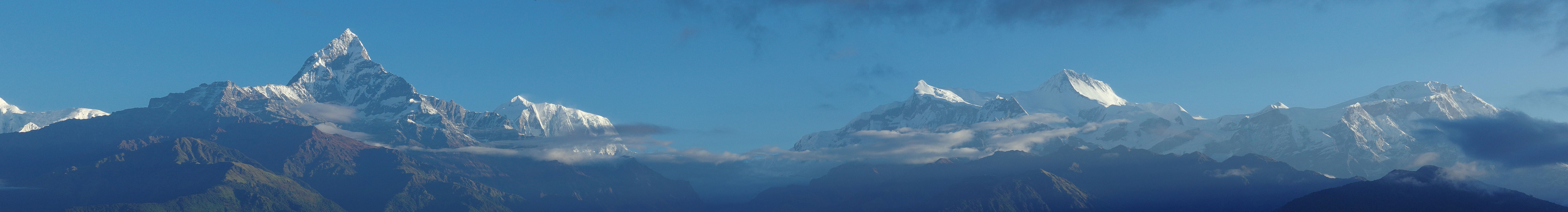
We climb up the ridge for a final panoramic view and they are all there: Annapurna South, Himchuli, Annapurna 1, Fish Tail, Annapurna 3, 4 and 2 and even Dhaulagiri, all on his own on the left hand side. A perfect farewell.
We descend slowly to the lake shores and stop in a guest house at the beginning of Lake Side: the trek is finished.
| Panorama of the Annapurna chain in Sarangkot. The big triangle on the left is Fish Tail (6993m), then comes Annapurna 3 (7555m) followed by a big gap. Up again to the right, you come to Annapurna 4 (7525m), Annapurna 2 (7937m) and finally, last on the right, Lamjung Himal (6983m) (clicking on the panorama opens a larger version in a separate tab, click again to activate scrolling in the full picture). |
 |
Don't forget to check our panorama page for more views of the Annapurna range along this part of the trek.
Go back to From Manang to Kagbeni or go on to Daman Detour
$ updated from: Around Annapurna.htxt Sun 24 May 2026 15:57:27 trvl2 — Copyright © 2026 Vero and Thomas Lauer unless otherwise stated | All rights reserved $