Welcome  Contact
FAQs  Links  News

France

La France… meilleur pays du monde (according to some).

Well. Let's face it: the French have it all. The highest mountains, the wildest coasts, amazing buildings, superb food, wines to die for… so what's not to like? (The frustrating strikes, perhaps?)

Full map of all France pages

Other Things

Translate & Share

Path: Photos > Photos > Landscapes > Along Brittany's Coastal Path > GR34: The North
Tags: France

GR34: The North


(vero;2019-March-30)

We have two galleries so far:

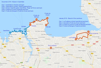
Some pictures taken during two one-week stays in the north of Brittany
Setting the scene… This gallery includes many pictures taken between Pointe du Meinga and Pointe du Grouin, a particularly delightful stretch of the coastal path. Unfortunately, although we do have a gallery dedicated to Saint-Malo below this one, we do not have pictures of our walks from Saint-Malo to Dinard and beyond but rest assured that they are really worth the effort. Also do not miss our photo section dedicated to the Mont Saint Michel (Map data ©2019 Google).
View of the Pointe du Chatry from the coastal path between Cancale and the Pointe du Grouin. The lighthouse of the Pierre-de-Herpin seen from the Pointe du Grouin. The semaphore of Pointe du Grouin seen from the west. The coast on the way to Pointe du Grouin (approaching from the west). The beach of la Saussaye, between Pointe du Meinga and Pointe du Grouin. Winter colours on the way between Pointe du Meinga and Pointe du Grouin. Somewhere between Pointe du Meinga and Pointe du Grouin. One of the beaches around the Havre de Rothéneuf between Rothéneuf and the Pointe du Meinga. Another bright winter day between Pointe du Meinga and Pointe du Grouin: the beach of La Saussaye in the foreground and the beach of Le Verger in the background. December 14 - What a beautiful day! The island Du Guesclin between Pointe du Meinga and Pointe du Grouin is cut from the mainland at high tide. It got its name from the old French noble family Du Guesclin who built a fortified castle on its ground in 1026 and was once the residence of the French singer Léo Ferré. Somewhere between Pointe du Meinga and Pointe du Grouin. Somewhere between Pointe du Meinga and Pointe du Grouin. Pointe after pointe, the coast between Pointe du Meinga and Pointe du Grouin. Based in Plouégat-Moysan, we explored the highly photogenic Côte de Granite Rose at Ploumanach between Perros-Guirec and Saint-Guirec but honestly, we thoroughly enjoyed every part of the coastal path we hiked through during this sojourn (Map data ©2019 Google). The roman church of Perros-Guirrec. Inside the church of Perros-Guirrec, note the beautiful capitals of the columns. The highly photogenic Côte de Granite Rose between Perros-Guirrec and Ploumanach/Saint-Guirec on a bright and sunny winter day. The Côte de Granite Rose between Perros-Guirrec and Ploumanach. The lighthouse of Men Ruz and the Maison du Littoral in Ploumanach on the Côte de Granite Rose. The Côte de Granite Rose. The lighthouse of Men Ruz in winter mid-January. The Château of Costaérès on the island of the same name across the small bay of Saint-Guirec. The church of Saint-Michel-en-Grève. The coast north of Saint-Michel-en-Grève in its winter coat. The sandy bay of Saint-Michel-en-Grève against the midday sun. Approaching Saint-Michel-en-Grève from the north. The coastal path between Saint-Michel-en-Grève and Le Yaudet. The coastal path between Saint-Michel-en-Grève and Le Yaudet. The coastal path between Saint-Michel-en-Grève and Le Yaudet. The coastal path between Locquirec and Saint-Jean-du-Doigt. The coastal path between Locquirec and Saint-Jean-du-Doigt. Cross in the churchyard of Saint-Jean-du-Doigt.

[Go to Top]


The Cité Corsaire of Saint-Malo and its neighbours Saint-Servan and Dinard
View of Saint-Malo from Saint-Servan.
View of Saint-Malo from Saint-Servan. View of Saint-Malo from Saint-Servan. The beach of the Môle below the city walls. View from the Pointe de la Vicomté, on the other side of the Rance estuary. Saint-Servan and the Tour Solidor are on the right, the island right of the middle is the rock de Bizeux with a statue of the Virgin on top. The seaside resort of Dinard is on the left of the picture. Saint-Servan and the Tour Solidor. The Tour Solidor in Saint-Servan. Its name comes from the Breton words steir and dor which mean gate of the river. The keep was built between 1369 and 1382 to control the river Rance and was the place where taxes were levied on traded goods. The Tour Solidor in Saint-Servan. The fort of Petit-Bé on the eponymous island is located a few hundred metres off the city walls of Saint-Malo and only accessible by foot at low tide. The tomb of François René de Chateaubriand, precursor of the French Romantic literature school and one of the great French writers of the 19th century. It is located on the island of Grand-Bé off Saint-Malo, which is only accessible by foot at low tide. The epitaph on the tomb reads: “A great French writer wanted to rest here to hear only the sea and the wind. Passer-by, respect his last wish”. The fort in the background is the fort of Petit-Bé (see previous picture). Breakwaters protecting the seawall of the long beach of Sillon linking Saint-Malo and Paramé: 3000 oak trunks regularly maintained and replaced over the years. The very first breakwaters are said to have been installed at the end of the 17th century. Chateaubriand who spent his childhood in Brittany and whose tomb is on the island of Grand-Bé off Saint-Malo mentioned them in his book “Memoirs from Beyond the Grave”.

[Go to Top]

Go back to Along Brittany's Coastal Path or go on to GR34: The West or go up to Landscapes


$updated from: Along Brittany's Coastal Path.htxt Mon 04 Mar 2024 16:04:47 trvl2 (By Vero and Thomas Lauer)$