Welcome  FAQs
Links  News

France

La France… meilleur pays du monde (according to some).

Well. Let's face it: the French have it all. The highest mountains, the wildest coasts, amazing buildings, superb food, wines to die for… so what's not to like? (The frustrating strikes, perhaps?)

Full map of all France pages

Other Things

Translate & Share

Path: Photos > Landscapes > Along Brittany's Coastal Path > GR34: Cornouaille
Tags: France

GR34: Cornouaille


(vero;2024-May-15)

We have two galleries so far. The first one includes pictures taken during a one-week sojourn near Quimper as well as some taken during a two-day car trip around Brest and the Pointe de Crozon. The second has pictures from our stay in Port Manech' in April 2022.

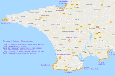
South Finistère - December 2018
South Finistère, with the Pointe du Raz and the busy fishing harbour of Le Guilvinec as two highlights of many (Map data ©2019 Google).
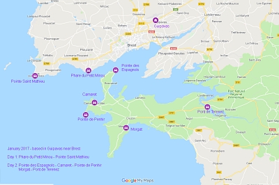
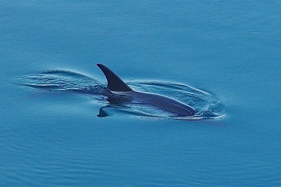
The chapel of Notre-Dame de la Joie in Saint-Guénolé. Cross with lichens in Saint-Guénolé. Sunset at the Pointe de Penmarch. Sunset at the Pointe de Penmarch. Cliffs at the Pointe du Raz. Approaching the Pointe du Raz. The small harbour of Bestrée, sheltered from the waves, just south of the Pointe du Raz. The lighthouse of La Vieille off the Pointe du Raz. The lighthouse of La Vieille off the Pointe du Raz with the island of Sein in the background. The Pointe du Raz. The lighthouse of La Vieille off the Pointe du Raz with the island of Sein in the background. The Pointe du Raz. Around the Pointe du Raz. The coast between Saint-Guénolé and Le Guilvinec. The calvary near the chapel of Notre-Dame de la Joie in Saint-Guénolé. Le Guilvinec. Every day the fishing boats arrive around 16:30 to unload their catch at the harbour. A highly touristy affair in the season with viewing platforms around to channel the tourists and let the fishermen work in peace. Not necessary in winter. Two days with the car touring the coast west of Brest and the Crozon peninsula (Map data ©2019 Google). View to the west from the Phare du Petit Minou. View to the east from the Phare du Petit Minou. Pointe Saint-Mathieu: ruins of the abbey of Saint-Mathieu de Fine-Terre. The lighthouse at Pointe Saint-Mathieu. The chapel of Notre-Dame de Rocamadour in the harbour of the small town of Camaret sur Mer. Camaret sur Mer. View across the harbour of Camaret with the chapel Notre-Dame de Rocamadour and the red Tour Vauban in the background. Pointe de Penhir, the rock formation known as Tas de Pois (pile of peas). Pointe de Penhir. The coast around the Pointe de Penhir. The coast around the Pointe de Penhir. A dolphin in the harbour of Morgat. The elegant bridge of Tenerez linking the Crozon peninsula to the mainland.
Port Manec'h - April 2022.
We hiked the coast east of the fortified city of Concarneau from our base in the hamlet of Kerambris near Port Manec'h. This part of the coast is broken by many fluvial valleys (called ria or aber) where the influence of the tide can be felt on a long distance inland. Those rias can be quite frustrating for the walker who once arrived at the mouth of a river sees the other side quite near but has to walk sometimes kilometres inland before finding a bridge to cross it (and back again on the other bank to regain the coast).
We stayed in a wonderful old farmhouse converted in gîtes right near the GR34. This is a view of the garden with its old stone walls and well. On the way to Port Manec'h with its lighthouse looming behind the rocks. The lighthouse of Port Manec'h. The picturesque and highly touristy village of Pont-Aven. The famous painter Paul Gauguin discovered Pont-Aven in the 1880s and was soon followed by many fellow painters whose paintings were inspired by the surroundings and Gauguin's so-called "Synthetism style". This community of artists and their works became known as the School of Pont-Aven. Pont-Aven lies inland right at the head of the ria of the river Aven, where freshwater meets the tidal waters. In the past, before tourism took over, the village was quite poor, one of its main resource coming from the water mills dotted along the ria; some are still standing but only the one featured on this picture (now a restaurant) boasts a still functioning wheel. An old tree on the path skirting the ria of the Aven. Old bread oven in one of the hamlets lining the ria of the river Aven. The coast near Port Manec'h has some very nice stone formations. This one would surely please Obelix. Another impressive rock with a view of the coast on the other side of the river Aven in the background. On the way to the Pointe de Trévignon. On the way to the Pointe de Trévignon. The path is clearly visible as it skirts the coast. Spring flowers along the way. The lighthouse at the Pointe de Trévignon The coast between Port Manec'h and the Pointe de Trévignon. This photo is a panorama, click the cross on the right below the photo (or press F if viewing on a desktop) to expand it to its real size and use the bottom scroll bar to navigate through it. Between Port Manec'h and the Pointe de Trévignon. Tide Mill over the ria of the river Minaouët on the way to Concarneau. Along the ria of the river Minaouët. The fort of Cabellou located at the eponymous pointe was built in 1746 to control the entrance of the Baie de la Forêt where the fortified town of Concarneau is located. The German recognised also the importance of the Pointe de Cabellou and made sure to have a few bunkers built there to strengthen their Atlantic Wall. View of the fortified city of Concarneau. This photo is a panorama, click the cross on the right below the photo (or press F if viewing on a desktop) to expand it to its real size and use the bottom scroll bar to navigate through it. Concarneau: statue of Abraham Duquesne, a famous French naval officer (1610-1688) who owned a manor house near Concarneau. The coast between Beg Porz and Poulguen. This photo is a panorama, click the cross on the right below the photo (or press F if viewing on a desktop) to expand it to its real size and use the bottom scroll bar to navigate through it. A small bay on the way between the Pointe de Kersecol and Doëlan. This photo is a panorama, click the cross on the right below the photo (or press F if viewing on a desktop) to expand it to its real size and use the bottom scroll bar to navigate through it. The mouth of the ria of Doëlan. This photo is a panorama, click the cross on the right below the photo (or press F if viewing on a desktop) to expand it to its real size and use the bottom scroll bar to navigate through it. Close-up of the mouth of the ria of Doëlan. The coast around Doëlan. Walking along the ria leading to Doëlan. The lighthouse of Doëlan.

[Go to Top]

Want to read more? Go back to GR34: Léon or go on to GR34: Vannetais or go back up to Along Brittany's Coastal Path


$ updated from: Along Brittany's Coastal Path.htxt Fri 16 Aug 2024 15:40:17 trvl2 — Copyright © 2024 Vero and Thomas Lauer unless otherwise stated | All rights reserved $