


Discovering the Weald
(vero;2025-Aug-15)
The place where London ends and England can begin. This quotation is from "The Old Song" by G.K. Chesterton and still rings true.
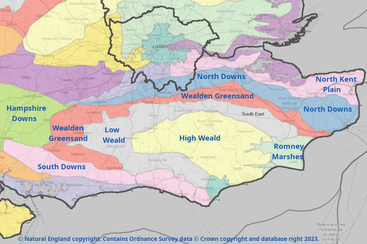
The Weald is a region separating the London Thames basin from the English Channel coast and includes parts of Kent, Sussex and Surrey; it is framed by the North and South Downs and can be divided into three parts (see map): the "Low Weald" is a broad low-lying clay valley which wraps around the sandstone outcrops of the "High Weald" and finally the Greensand Ridge which extends around the north and west of the Weald and where its highest points can be found.
 During Saxon times, much of the Weald was covered in thick forests (the word derives from the Germanic word Wald meaning forest) reaching from the Romney Marshes in Kent to the New Forest in Hampshire. The presence of iron in the Wealden sandstone with the additional presence of large amounts of timber for making charcoal for fuel, has contributed to the establishment of the area as an important centre of iron industry until the beginning of the 19th century (the last forge closed in 1813).
 Over the centuries, the Weald is thought to have undergone repeated cycles of clearance and re-forestation; much of the forest has disappeared but the region still retains many woodlands. It is nowadays mostly characterised by gentle hills, ridge roads, sunken country lanes and sleepy villages. The soil is often not fertile enough for agriculture, it is a land of orchards, hop fields and cattle breeding (the Weald has its own breed of cattle, the so-called Sussex cattle). Thanks to its mild climate, the region has recently turned to growing wine on its slopes with much success.
The Weald's location thirty miles south of London and half way to the South coast has long made it a strategic region counting many castles and fortified houses in case of possible invasions. It was an isolated region populated by farmers and iron workers until the 19th century. That's when the London gentry and aristocracy discovered the area thanks to the expansion of the railways and realised it would be a great place to have a get-away from the capital while at the same time remaining in easy distance of it. Some purchased land and estates, restoring or expanding former existing manor houses or castles, many of which dated back to the medieval and Tudor times, while others simply built their new homes from scratch. We were amazed at the number of castles and rich stately homes and estates dotted around the landscape.
We spent three busy days in the Weald in August 2025; we pitched our tent at the Apple Acres campsite near the town of Royal Tunbridge Wells, which was a good location to explore the High Weald. We combined visits to some National Trust properties with a bit of walking (to avoid paying the parking fees!).
Our first day was an overdue visit to Hever Castle, something we kept wanting to do but never got to. The next day, we visited Sissinghurst Gardens and Royal Scotney Castle and on our final day, we drove to Bodiam Castle, continued to Bateman's (home of Rudyard Kipling) before heading home with a detour north of Haywards Heath to see the highly photogenic Ouse Valley Viaduct.
We have photo galleries for each site:
| Hever Castle | Sissinghurst Castle Garden | Scotney Castle | Bodiam Castle | Bateman's |
Want to read more? Go back to Kenilworth Castle: fit for a Queen or go on to West Country 2025 or go up to Blog
$ updated from: Blog.htxt Sun 24 May 2026 15:57:33 trvl2 — Copyright © 2026 Vero and Thomas Lauer unless otherwise stated | All rights reserved $